As so often happens on the interweb, I found myself lost in a rabbit hole of complexity where naively I had expected to find simplicity. What began as a plan to explain to Cliscep readers the basics of the sceptic’s favourite spicy sauce, “global greening,” soon became complicated because the facts themselves are complicated. For example, there is a vegetation index that I am familiar with and know how to calculate*, which is one that has shown greening in the satellite era. However, only now reading the wider literature on global greening, I soon found out that my simple index is actually fiendishly difficult to interpret. For that reason among others, I’m not going to talk about global greening right now – that will have to wait for another day. Instead I’m going to tell you about one of the innumerable side-branches of the rabbit warren I found myself in.
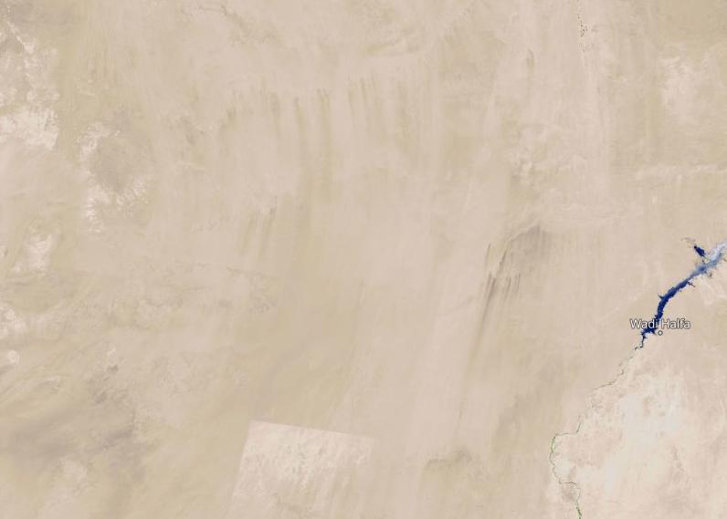
I was looking for a good place to illustrate the basic concept of a gradual change in greenness over time since the dawn of the satellite era. To that end I thought somewhere in the Sahel would be a good model. On Nasa’s excellent Worldview website**, you can display many data layers, including vegetation indices. With Landsat you can go back to about 1983, and data from Terra/Aqua become available I think in 2002. So I was looking at the NDVI record for North Africa from outer space, scrolling through time, looking for a place that might make an exemplar of the theme, when I spotted what looked like a sudden blossoming of life not at the join between Sahara and Sahel but in pure desert – once utterly lifeless sand in the middle of nowhere suddenly lighting up the NDVI scale.

Naturally I had an idea what was going on, but nevertheless it didn’t seem to make a great deal of sense. So I turned to Google Earth in hopes that someone had helpfully uploaded geolocated photographs of the site, or else that it would be labelled with a place name that I could look up elsewhere.
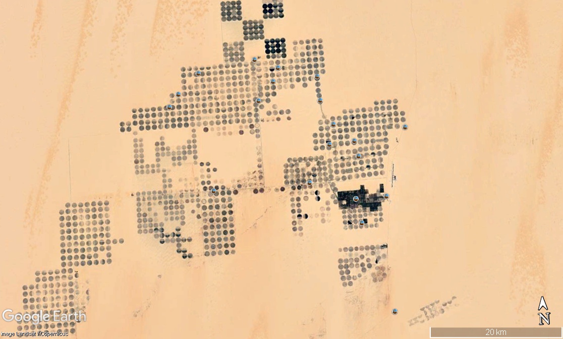
Luckily for this puzzle, a contributor called Ragab Hafiez had uploaded some photographs of the area. The first photograph I saw was what looked like barley – a typical British crop growing in the middle of the Western Desert. Another photo showed what looked like alfalfa, and others showed workers harvesting… potatoes. What gives?

42′ N, 28° 24′ E).
Well, of course this is no natural greening caused by the CO2 fertilisation effect. This is the result of irrigation. Under the desert sand, there is water. If you put a borehole deep enough, you can reach it. Then you can simply pump out water and make it rain.
The circles on the Google Earth image are at 1 km centres, and each is 800 m in diameter (i.e. the area of each is about half a square kilometre). The irrigation systems are giant booms – obviously 400 m in length – that sweep around a central axis. The whole site (East Owainat) is easily 50 km across.
Is sucking water out of the ground to grow barley in a desert with essentially zero actual rainfall a good idea? Obviously it’s harder to grow barley in the Western Desert than, say the flatlands of Cambridgeshire. I can imagine that sandstorms threaten to bury everything, for a start. The desert is obviously sunnier, but it’s also hotter – Kharga, the nearby oasis (nearby-ish; don’t try to walk it) has an average June maximum of 40°C and a record temp of 50°C. The aquifer is going to deplete over time (according to El Alfy (2014)^, the aquifer is going down at a rate of 0.5 m per year; its thickness seems to be quite variable). Aquifer depletion generally has the potential to cause sinkholes, but here my naïve guess is that because the surface is “obviously” sandstone, there are no subsurface caverns primed to open up under the farm workers’ feet.
Why start farming in the middle of nowhere? Why not close to an existing oasis like Kharga? Well, the existing oasis already has water. And one presumes that Kharga sits at the level of the aquifer, such that local water extraction would rapidly cause obvious problems – the water at the surface would begin to disappear. No doubt the theory behind the choice of East Owainat is that it is far enough from anywhere that no amount of aquifer depletion will affect anyone else.
Why barley? Why not a plant with C4 photosynthesis, which is more productive in hot and dry conditions (maize for example)? I have no answer to that.
Nor do I know how long the desert at East Owainat will remain green. Triumph of human ingenuity, or hubristic folly?
This miniature has no direct link to climate change. Or does it? I will leave it to the reader to decide whether or not the cultivation of barley in the Western Desert might be relevant to claims about the way future agricultural productivity might be affected by the “climate crisis”.
Notes & References
You might have noticed another change between the 1986 and 2010 images. Over to the right of the second image, there is a dark area that wasn’t there in the first. These are the Toshka Lakes, fed by an overflow from Lake Nasser. These might give rise to a rapid bounty of fish and crops, but one suspects this will be temporary. The lakes are filled occasionally, and of course rapidly evaporate. Naturally over time this will lead to the concentration of minerals in the water going up.
*NDVI. “Normalised Difference Vegetation Index.” I think this was the first one invented for use with Landsat images in the 1970s. It is based on the idea that plants absorb more red light and reflect more infrared than bare ground. Now, I know what you’re thinking. Plants are green, so why do we need an index involving red and infrared? Why not just measure green? Well, if you remember those far-off days in gloomy classrooms, playing with triangular prisms and watching dust motes swarm in the gleam cutting in around the edge of the blinds, you’ll also remember that white light contains green. Plants appear green because they have preferentially absorbed blue and red light. What I am trying to get at is that a white surface (e.g. snow) has as much green light coming off it as, say, a municipal lawn.
**Worldview.earthdata.nasa.gov
^El Alfy, M. (2014). Numerical groundwater modelling as an effective tool for management of water resources in arid areas, Hydrological Sciences Journal, 59:6, 1259-1274. [Gettable from Google Scholar.]

Apologies if you are already aware of these references:
https://www.nature.com/articles/srep20716
https://www.nature.com/articles/nclimate3004
https://www.csiro.au/en/News/News-releases/2013/Deserts-greening-from-rising-CO2
I have several more if you’re interested.
LikeLike
I assume that only water is the added factor (via the aquifer) here? I am interested to learn that alfalfa and (apparently) potatoes can be grown in sand. I naively wonder whether the existence of growing crops can have any impact at all on the climate? Or whether this will just be a short-term experiment that fails if and when the aquifer runs dry.
LikeLiked by 2 people
Is sucking water out of the ground to grow barley in a desert with essentially zero actual rainfall a good idea?
The amount of rainfall is irrelevant — what matters is how much water gets there. There’s plenty of places with little rainfall with massive rivers flowing through, after all.
The aquifers arose for a reason, and that is because water that rains elsewhere is presumably flowing down to that point.
LikeLike
The key question is the recharge rate of the aquifer compared to the extraction rate. Already the aquifer levels are falling suggesting that extraction exceeds recharge. My guess is the water in this region recharged a long time ago. The water is effectively being mined. It’s not widely recognised but many aquifers are full of water recharged a long time ago, even in temperate regions. In Norfolk, significant areas of the chalk aquifer, notably beneath boulder clay in the interfluve regions, were recharged more than 10,000 years ago. The active recharge areas are only in the valleys where there is a dynamic groundwater flow.
LikeLiked by 1 person
Thanks Cat, no I have not read those, although the Nature Climate Change paper was already on my reading list (which is quite extensive, as is the literature). The existence of the trend is clear (although seemingly overlooked in certain quarters). The reasons for it differ from place to place, & not all is to do with the CO2 fertilisation effect.
Mark, one of the companies operating the farms is http://www.eastowainat.com/EN/company?i=30. They have if my reading is right 10*10km, on which they are allowed 80 of the discs.
They say (autotranslated): “the soil is sandy and under it is a red layer mixed with silt and the soil analyzes are excellent”. I imagined several metres of sand, but…
Chester/Paul – without knowing anything about hydrology I supposed the water was ancient. Presumably removing some increases the inward flow for a time. Presumably too, one could simply bottle the water and sell it to Western restaurants as ancient water from the Sahara Desert. Or am I too cynical to think that diners would buy it?
LikeLiked by 1 person
I’m sorry, Jit, but I come to this article today (and sorry to be late) and it sounds all sciency and stuff, with what appear to be good-faith caveats about highly complex matters, but yesterday, on Sunday with Laura Kuenssberg, I had the privilege of listening to Christiana Figueres and she made it totally clear that drought, famine and current high food prices are completely due to man’s addiction to fossil fuels and nothing else. She was completely clear about this and I know she must have been speaking the truth because Laura Kuenssberg, who normally is very happy to interrupt and challenge the average politician, didn’t say a peep that might have risked being thought the slightest bit sceptical about these statements.
iPlayer link here, which you and your readers would obviously benefit from. Please don’t thank me too much.
[Oops, got the link wrong. Now corrected.]
LikeLiked by 3 people
I gave up watching Kuenssberg when I realised that she was very good at politics but not very good at general logic. There’s only so many times you can sit there screaming the obvious question at the TV before you realise that you’re watching a different interview to the one you hoped you were watching.
LikeLiked by 3 people
To return to the (quasi-)sciency bits, you can deduce something about the aquifer from information visible on the Landsat images.
First the colour variation between (and sometimes within ) the irrigation circles does not represent different crops. Instead it represents the wetness of the soil -a variation of which reflects the time between when the photograph was taken and the time the ground was irrigated. Dark colours represent still wet soils whereas the change in tones towards that of the unirrigated desert show the progressive drying out of the irrigated circles and thus their relative age. This suggests the aquifer is quickly being depleted (and so the active area has migrated as the older circles are abandoned). The aquifer is therefore probably thin and most likely shallow. (The cost of drilling hundreds of wells to a deep aquifer would be overly expensive) It also suggests that only small parts of the area underlain by the aquifer are currently being irrigated or are producing crops. The large size of the area is deceptive.
LikeLiked by 2 people
Thanks, Jit. Egypt’s desert-irrigation schemes are fascinating – and often wildly implausible. You thoroughly rabbitholed me.
I haven’t been able to find a detailed plan of the long-abandoned later phases of the Toshka project that you mentioned. The best was this very broad-brush Norwegian map that someone tweeted:
https://pbs.twimg.com/media/EY_lInSWAAEy6tX?format=jpg&name=medium
That and other sources say that the canal was to have gone all the way from Lake Nasser to the Farafra oasis, which is on a highish plateau. I visited it once (on an uninsured motorcycle with Saudi number plates that I’d faked myself with rubber and glue – happy, foolish days!) and, from memory, it’s two or three hundred metres above the desert floor. How did they plan to get a 200m-wide canal up there? And why?
Prof Google suggests that Toshka/New Valley was all about political posturing and corruption. Billions spent even though nobody ever really expected it to be completed.
Phase 1 has been revived, though. Some sites say that this was in response to Russia’s invasion of Ukraine (because Egypt was worried about wheat supplies) but it was actually revived in 2019. Not sure why.
Back down the rabbithole…
LikeLiked by 1 person
Alan, you might be right. I don’t know. If only we had a regular commenter who was also a hydrologist in real life.
From the photos on Google Earth, I can say for sure that a lot of water is being wasted – basically squirted out and almost instantly evaporated. (But presumably this also cools the ground.) They could certainly make more effective use of the water rather than misting it over the crop. There must be subsurface irrigation equipment.
Vinny, I am hearing the theme tune to Indiana Jones.
LikeLiked by 1 person
Congratulations to the rabbitholer and the rabbitholee. But I want to go back to the motivation of the rabbitholer.
I liked the post (in the WordPress sense) when I reached the end but I would have done so for this sentence alone. How obviously true, and honourable, and honest. The true scientist at work or at least getting started.
But it also rang two recent bells for me. The first I’ve mentioned – watching Christiana Figueres be so certain and thus unscientific about such related (and far more) complex things (even than global greening). She explained how she’d been meeting with women in the UK struggling to afford food. I thought “You must have got down on your knees to beg forgiveness for your part in making their plight so much worse.” But no and thrice no. I’ll come back to my resulting sense of outrage on another thread. It’s the second recent outrage-incident for me, the first being triggered by The Guardian. They do so hunt in pairs. Sorry I had to get it (partly) off my chest here.
The other bell had to do with Freeman Dyson’s views on global greening. He said it was certainly happening – the data was by 2015 incontrovertible. I used that in my big post contra BBC imbalance in 2019. And just before reading this one I came across some debate I had on Twitter in 2020 about this very thing. Here are six tweets that should give the reader the gist and allow them to discover more, if required.
So this for me is about not getting rabbitholed but trusting an expert who’d been looking at the issue for 49 years when I was writing. Is that allowed? Why? Well, because from his writings I’d detected the same commitment to the scientific method that impressed me in Jit’s starting sentence. And a pretty unusually-sized brain and a lot of time to devote to the subject. Anyway that was the second bell.
LikeLiked by 1 person
JIT but I picked up much hydrological lore from two bono fide hydrologists during my stint at UEA. For more than 15years I taught classes on the subject of fluid flow through porous media. None of this helped me in my attempts to unravel the secrets of the Egyptian desert and its aquifer. Doing this, however, does not require much hydrological knowledge.
The huge number of irrigation circles implies an equally large number of drilled wells. If the aquifer had been deep, the cost of all those wells would have been extreme. I cannot believe the cost would be offset by vegetables!
If the aquifer is shallow then it must also be widespread, extending across d distance of more than 30km.
Could the aquifer be surface sands that have collected floodwaters of the Nile: a small part of which escaped evaporation?
LikeLike
Alan, the paper I referred to says this:
It sounds like the water comes from a long way away, and takes quite a long time to make the trip. But I suppose it’s more like a conveyor belt. You can read more of El Alfy’s paper at Researchgate.
Richard, thank you for the kind words. As I always say, it should be more important to find the correct answer than to win the argument!
LikeLiked by 2 people
What we need to do is grant legal personhood to water.
Or so the Beeb said an hour or so ago when it gave this bonkers 2020 TED* talk another airing:
https://www.bbc.co.uk/programmes/m000zm4k
===
*TED = Tendentious Egocentric Drivel?
LikeLiked by 2 people
JIT, time for some humility about my personal hydrological expertise. The paper you recommended provides the evidence needed for my hydrological downfall. It reveals that the aquifer consists of a thick lowermost part of the widespread Nubian Sandstone. It is not possible to read the illustrations numbers on my I-Pad but it looks like the highly variable aquifer thickness locally exceeds a hundred metres, far exceeding my conclusion that the aquifer was a thin one. (Nevertheless if the aquifer is only tapped in its uppermost parts….)
There is one howler – a diagram showing the changing top surface of the aquifer over time . This is based on measurements on selected wells. This is a standard practice but assumes nothing occurs or changes between the wells . In this instance there could be up to 100 neighbouring wells either pumping out water or at rest and influencing the aquifer and its upper surface. Their maps and everything that is written about them is thereby meaningless.
(Hydrologic honour partially restored)
LikeLiked by 1 person
Alan, had I thought about it a bit I guess it was obvious. Somewhere in the paper it describes the thickness of the sandstone, but I looked in vain for the thickness of the aquifer. Of course since sandstone is porous, everything below the water level must be wet, all the way down to the basement impermeable rock.
It’s not just your iPad. The figures are not very good, in fact they are mostly illegible.
Even if the aquifer is deep, there is presumably still the potential for local drops to pull water from elsewhere, potentially affecting far-off oases.
LikeLiked by 1 person
I had meant to write this at a more appropriate time, but it skipped my mind. The question was asked: why barely? I suggest that it was because barley is more tolerant of drought and water salinity than other grains. Indeed if the water has travelled far and has spent much time underground then it is likely to be be somewhat saline. Exposure to direct sunlight, causing immediate evaporation, will exacerbate the problem, such that in many places watering is better conducted at night.
LikeLike
Evil spellchecker: barley not barely.
LikeLike